
Contact us for a FREE bike map
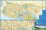
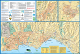
The Santa Cruz County Regional Transportation Commission (RTC) provides a countywide bikeways map showing bicycle lanes, paths, alternate routes and unpaved multiuse trails. The full color map is 24 X 36 inches and folds down to 4 X 9 inches making it easy to carry while riding a bike. The map features detailed insets of the San Lorenzo Valley, Scotts Valley, Watsonville, and Santa Cruz to La Selva Beach areas as well as major attractions, schools, transit centers, bike shops, parks, campgrounds and hostels. Important resources including phone numbers and websites for bicycle organizations have been updated, and law enforcement contact information is also included. Safety tips are shown in both English and Spanish.
Free printed copies of the 2016 Santa Cruz County Bike Map can be picked up at 1101 Pacific Ave Suite 250, Santa Cruz, CA 95060. Call (831) 429-POOL or email info@sccrtc.org for other pickup locations such as bike shops, Bike to Work/School, Open Streets and other outreach events. The Santa Cruz County Bike Map is available online as a PDF. Download a copy of the 24″ x 36″ map:
County-Wide
Local Cities
(Note: file size exceeds 5 MB per side)
Cruz511 in Your Neighborhood Bike Maps
Cruz511 In Your Neighborhood was a pilot program designed to connect with people who are interested in leaving their car at home and making changes in their travel behavior. The Cruz511 In Your Neighborhood Bike Maps provide a neighborhood level of detail for the Central Watsonville and Eastside and Downtown Santa Cruz neighborhoods. RTC staff are seeking funding to provide maps for other neighborhoods in Santa Cruz County. At this time, the Eastside and Downtown Santa Cruz and Central Watsonville Bike Maps are only available online — printed copies are subject to funding availability.

Eastside and Downtown Santa Cruz (Spanish Version)

Central Watsonville (Spanish Version)
Bicycle Route Signage Program
The RTC installed bicycle wayfinding signage at 303 locations throughout the county to assist all types of bicycle riders – commuters, families, recreational riders and visitors – in finding and accessing 53 major destinations throughout the county. View the preferred route web map (2020).
Other Bike Maps
- Google Maps has a detailed bicycle layer that includes bike paths, dedicated lanes, bicycle-friendly roads, and unpaved bike trails. Use it at home or on the road with a mobile device. Use the Google Map to get directions and plan your trip by bike.
- Watsonville Slough Trails Map – 5 miles of trails through one of the largest remaining freshwater wetlands along the Central Coast.


